Showing posts with label philippine weather. Show all posts

Wednesday, August 15, 2012

Severe Weather Bulletin Number 13 - 11:00 p.m., 15 August 2012


Weather Bulletin Number 13
Tropical Cyclone Warning: Tropical Storm "HELEN" (KAI-TAK)
Issued at 11:00 p.m., Wednesday, 15 August 2012 

Tropical Storm "HELEN" has accelerated as it moves in a West Northwest Direction.  

Location of Center:   190 km West Northwest of Laoag City
(as of 10:00 p.m.) 

Coordinates:     19.3°N, 118.8°E 

Strength:     Maximum sustained winds of 75 kph near the center and
                    Gustiness of up to 90 kph

Movement:     West Northwest at 22 kph

Forecast Positions/Outlook:

Thursday morning - Expected to be out of the Philippine Area of Responsibility (PAR) or
                                  at 230 km West Northwest of Laoag City

Areas Having Public Storm Warning Signal 

Signal No. 1 (45-60 kph winds) 
  • Batanes Group of Islands
  • Cagayan
  • Calayan
  • Babuyan Group of Islands
  • Ilocos Norte
  • Ilocos Sur
  • Kalinga
  • Apayao
  • Benguet
  • La Union
  • Abra
  • Mt. Province
  • Ifugao

Public Storm Warning Signal elsewhere now lowered.

Residents living in low lying and mountainous areas under public storm warning signal #1 are alerted against possible flashfloods and landslides.

Tropical Storm "HELEN" will continue to enhance the Southwest Monsoon that will bring rains over the rest of Luzon and Visayas particularly over the western section.

Estimated rainfall amount is from 15 - 25 mm per hour (heavy - intense) within the 500 km diameter of the Tropical Storm.

Moderate to occasionally heavy rains (5.0 - 10.0 mm/hr) and moderate to occasionally strong winds are expected over Metro Manila, Central Luzon and Southern Luzon tonight.

Fishing boats and other small seacrafts are advised not to venture out into the seaboards of Central and Southern Luzon and Visayas due to Tropical Storm "Helen" and the Southwest Monsoon.

The public and the disaster coordinating councils concerned are advised to take appropriate actions and watch for the next bulletin to be issued at 5 AM tomorrow.  

---------------------------------------------------------------------------------------------------------
PAGASA-DOST | August 15, 2012 | Article Link

Tuesday, August 14, 2012

Severe Weather Bulletin Number 8 - 5:00 p.m., 14 August 2012


Severe Weather Bulletin Number 8
Tropical Cyclone Warning: Tropical Storm "HELEN" (KAI-TAK)
Issued at 5:00 p.m., Tuesday, 14 August 2012 

Tropical Storm "HELEN" has intensified slightly as it moves closer to Northern Luzon.  

Location of Center:   230 km East Southeast of Tuguegarao City
(as of 4:00 p.m.) 

Coordinates:     17.3°N, 124.2°E

Strength:     Maximum sustained winds of 85 kph near the center and
                    Gustiness of up to 100 kph

Movement:     Northwest at 13 kph

Forecast Positions/Outlook: 

Wednesday afternoon - 180 km North of Tuguegarao City or
                                       70 km North of Aparri, Cagayan
Thursday afternoon -
380 km Northwest of Aparri, Cagayan or
                                    300 km West Northwest of Basco, Batanes

Areas Having Public Storm Warning Signal 

Signal No. 2 (61-100 kph winds) 
  • Cagayan
  • Calayan Grp. of Islands
  • Babuyan Grp. of Islands
  • Isabela
  • Apayao
  • Kalinga
  • Ilocos Norte
  • Abra
  • Batanes Grp. of Islands

Signal No. 1  (45-60 kph winds) 
  • Aurora
  • Quirino
  • Nueva Vizcaya
  • Ifugao
  • Benguet
  • Mt. Province
  • La Union
  • Ilocos Sur

Residents living in low lying and mountainous areas under public storm warning signal #2 and #1 are alerted against possible flashfloods and landslides. Likewise, those living in coastal areas under public storm warning #2 are alerted against big waves or storm surges generated by this tropical cyclone.

Tropical Storm "HELEN" will enhance the Southwest Monsoon that will bring rains over Luzon and Visayas especially over the Western section.

Estimated rainfall amount is from 20 - 35 mm per hour (intense - torrential) within 500 km diameter of Tropical Storm.

Intermittent light to moderate rains (2.5 - 7.5 mm/hr) over Central and Southern Luzon becoming more frequent moderate to heavy rains (7.5 - 10.0 mm/hr) in Quezon province, Rizal, Bulacan, Pampanga, Laguna, Cavite, Batangas, Mindoro, Bataan, Zambales, Pangasinan, Tarlac and Metro Manila.

Fishing boats and other small seacrafts are advised not to venture out into the Seaboards of Central and Southern Luzon and Visayas due to Tropical Storm "HELEN" and the Southwest Monsoon.

The public and the disaster coordinating councils concerned are advised to take appropriate actions and watch for the next bulletin to be issued at 11 PM today.  

--------------------------------------------------------------------------------------------------------------
PAGASA-DOST | August 14, 2012 | Article Link

Severe Weather Bulletin Number 7 - 11:00 a.m., 14 August 2012


Severe Weather Bulletin Number 7
Tropical Cyclone Warning: Tropical Storm "HELEN" (KAI-TAK)
Issued at 11:00 a.m., Tuesday, 14 August 2012 

Tropical Storm "HELEN" has maintained its strength as it continues to move towards Northern Luzon.  

Location of Center:   230 km East Northeast of Casiguran, Aurora
(as of 10:00 a.m.)

Coordinates:     16.8°N, 124.8°E 

Strength:     Maximum sustained winds of 75 kph near the center and
                   Gustiness of up to 90 kph

Movement:     West Northwest at 13 kph

Forecast Positions/Outlook:  

Wednesday morning - 50 km North Northeast of Tuguegarao City
Thursday morning -
270 km West Southwest of Basco, Batanes
Friday morning -
550 km Northwest of Laoag City

Areas Having Public Storm Warning Signal  

Signal No. 2 (61-100 kph winds) 
  • Cagayan
  • Calayan
  • Babuyan
  • Grp. of Islands
  • Isabela
  • Apayao
  • Kalinga
  • Batanes Grp. of Islands

Signal No. 1 (45-60 kph winds) 
  • Quirino
  • Aurora
  • Nueva Vizcaya
  • Ifugao
  • Benguet
  • Mt. Province
  • Ilocos Sur
  • Abra
  • Ilocos Norte

Residents living in low lying and mountainous areas under public storm warning signal #2 and #1 are alerted against possible flashfloods and landslides. Likewise, those living in coastal areas under public storm warning #2 are alerted against big waves or storm surges generated by this tropical cyclone.

Tropical Storm "HELEN" is expected to enhance the Southwest Monsoon that will bring rains over Luzon and Visayas especially over the Western section.

Estimated rainfall amount is from 15 - 25 mm per hour (heavy - intense) within 500 km diameter of Tropical Storm.

Intermittent light to moderate rains (2.5 - 7.5 mm/hr) are now affecting Central and Southern Luzon becoming more frequent moderate to heavy rains (7.5 - 10.0 mm/hr) today over Camarines provinces, Quezon province, Rizal, Bulacan, Pampanga, Laguna, Cavite, Batangas, Mindoro, Bataan, Zambales, Pangasinan, Tarlac and Metro Manila.

Fishing boats and other small seacrafts are advised not to venture out into the Seaboards of Central and Southern Luzon and Visayas due to Tropical Storm "HELEN" and the Southwest Monsoon.

The public and the disaster coordinating councils concerned are advised to take appropriate actions and watch for the next bulletin to be issued at 5 PM today.  

---------------------------------------------------------------------------------------------------------------
PAGASA-DOST | August 14, 2012 | Article Link

Monday, August 13, 2012

Severe Weather Bulletin Number 3 - 11:00 a.m., Monday, 13 August 2012


Severe Weather Bulletin Number 3
Tropical Cyclone Warning: Tropical Storm "HELEN"
Issued at 11:00 a.m., Monday, 13 August 2012 

Tropical Depression "HELEN" has intensified into a Tropical Storm and is now threatening Northern Luzon.  

Location of Center:   550 km East Northeast of Casiguran, Aurora
(as of 10:00 a.m.) 

Coordinates:     17.2°N, 128.0°E 

Strength:     Maximum sustained winds of 65 kph near the center and
                    Gustiness of up to 80 kph

Movement:      West Northwest at 13 kph

Forecast Positions/Outlook:

Tueday Morning - 330 km East Northeast of Tuguegarao City
Wednesday Morning - 80 km North Northeast of Aparri, Cagayan

Thursday Morning - 220 km West of Basco, Batanes

Areas Having Public Storm Warning Signal 

Signal No. 1  (45-60 kph winds)
  • Isabela
  • Kalinga
  • Apayao
  • Cagayan
  • Babuyan
  • Calayan Grp. of Islands
  • Batanes Grp. of Islands

Residents living in low lying and mountainous areas under public storm warning signal #1 are alerted against possible flashfloods and landslides.

Tropical Storm "Helen" is expected to enhance the Southwest Monsoon that will bring rains over Luzon and Visayas especially over the western section.

Estimated rainfall amount is from 15 - 35 mm per hour (heavy - torrential) within 400 km diameter of Tropical Storm.

Intermittent light to moderate rains (2.5 - 7.5 mm/hr) are now affecting Central and Southern Luzon becoming more frequent moderate to heavy rains (7.5 - 10.0 mm/hr) during the latter part of the day towards the evening over Camarines provinces, Quezon province, Rizal, Bulacan, Pampanga, Laguna, Cavite, Batangas Mindoro, Bataan, Zambales and Metro Manila.

The public and the disaster coordinating councils concerned are advised to take appropriate actions and watch for the next bulletin to be issued at 5 PM today.
 
-------------------------------------------------------------------------------------------------------------
PAGASA-DOST | August 13, 2012 | Article Link

Friday, August 10, 2012

Weather Advisory No. 8 - 11:00 AM, 10 August 2012

Weather Advisory No. 8
For: Southwest Monsoon
Issued at: 11:00 AM, 10 August 2012

The Southwest Monsoon (HABAGAT) will continue to bring mostly cloudy skies with scaterred rainshowers and thunderstorms becoming cloudy with widespread rains over Northern and Central Luzon particularly along the provinces of Ilocos, La Union, Pangasinan, Zambales, Pampanga, Bataan, Tarlac and Bulacan.

Residents living in these areas are warned against threats of flashfloods and floods in low lying areas and landslides in mountainous areas.

The next update will be incorporated in the Public Weather Forecast at 5:00 pm today while the next advisory will be issued at 11:00 am tomorrow.

----------------------------------------------------------------------------------------------------------------
PAGASA-DOST | August 10, 2012 | Article Link

Thursday, August 09, 2012

Rainfall Warning - 11:30 AM, 09 August 2012

Code: Yellow Warning
Based on the 11:00AM observation
Issued at: 11:30 AM, 09 August 2012


Moderate rainfall (5.0-7.5 mm/hr) was observed over CAMANAVA while Light to Moderate rainfall (1.0-5.0 mm/hr) over Quezon City and Manila.

People are advised to MONITOR for the next update. pagasadost

-------------------------------------------------------------------------------------------------
PAGASA-DOST | August 9, 2012 | Article Link

Rainfall Warning - 11:00 PM, 08 August 2012

Code: Yellow Warning
For: Metro Manila
Issued at: 11:00 PM, 08 August 2012

Heavy rainfall (7.5-22.0 mm/hr) over QC, Manila, Caloocan, Moderate to Heavy rainfall (2.5-7.5 mm/hr) was recorded over Pasig & Marikina while Light to Moderate rainfall (1.0-7.0 mm/hr) over the rest of Metro Manila.

Due to the effect of the series of thunderstorms embedded in the Southwest Monsoon, expect Moderate to Heavy (5.0-10.0mm/hr) rains with occasional Heavy to Intense (15.0-30.0mm/hr) rains over QC, Manila, Pasig, CAMANAVA, San Juan, Mandaluyong, Marikina and nearby areas within 2hrs.

Residents in flood/landslides risk areas are advised to take precautionary measures and WATCH OUT for the next warning. 
  

-----------------------------------------------------------------------------------------------------
PAGASA-DOST | August 8,2012 | Article Link


Wednesday, August 08, 2012

Rainfall Warning - 06:50 PM, 08 August 2012

Code: Yellow Warning
For: Metro Manila
Issued at: 06:50 PM, 08 August 2012

Heavy to Intense rainfall (15.0-27.0 mm/hr) over QC & Marikina, Moderate to Heavy rainfall (8.0-12.0 mm/hr) was recorded over Manila and Pasig while Light to Moderate rainfall (1.0-7.0 mm/hr) over the rest of Metro Manila.

Expect Light to Moderate (2.5-7.0 mm/hr) rains w/ occasional moderate to heavy (8.0-15.0 mm/hr) rains over QC, Marikina, Manila, Pasig and nearby areas within 2 hrs.

Residents in flood/landslides risk areas are advised to take precautionary measures and WATCHOUT for the next warning. 
 
------------------------------------------------------------------------------------------------------------


 PAGASA-DOST | August 8, 2012 | Article Link             


Weather Advisory No. 6 - August 8, 2012


Weather Advisory No. 6
For: Southwest monsoon
Issued at: 11:00 AM, 08 August 2012

The Southwest Monsoon (HABAGAT) has weakened slightly as Tropical Cyclone "HAIKUI" outside the Philippine Area of Responsibility has moved farther away and made landfall in the vicinity of Shanghai, China early this morning. Consequently, weather condition is expected to slightly improve further before the weekend because of the weakening of the southwesterly winds. However, for the next 12 hours, light to moderate rains (2.5-5mm/hr) in some portions of Batangas are expected. Intermittent moderate to heavy (5-10mm/hr) but less frequent rains compared with the past 24-hours will be experienced in the following Provinces: Portions of Pangasinan, Nueva Ecija, Pampanga, Tarlac, Bulacan, Bataan, Rizal, Cavite and NCR.

Threats of flashfloods and floods in low lying areas and landslides in mountainous areas as well as Lahar flows over Pinatubo will gradually decrease.

Residents living in those areas are still warned against the danger of these hazards that may occur.

Disaster managers are still alerted to continually take precautionary measures.

The next update will be incorporated in the Public Weather Forecast at 5:00 pm today while the next advisory will be issued at 11:00 am tomorrow.

------------------------------------------------------------------------------------------------------------
PAGASA-DOST | August 8, 2012 | Article Link

Thursday, June 28, 2012

Severe Weather Bulletin Number 9 - June 28,2012 - Tropical Storm Dindo


Severe Weather Bulletin Number 9
Tropical Cyclone Warning: Tropical Storm "DINDO" (DOKSURI)
Issued at 5:00 p.m., Thursday, 28 June 2012 

Tropical Storm "DINDO" continues to threaten Extreme Northern Luzon as it moves closer.  
------------------------------------------------------------------------

Location of Center:   140 km North Northeast of Aparri, Cagayan
(as of 4:00 p.m.) 

Coordinates:     19.7°N, 122.3°E 

Strength:     Maximum winds of 75 kph near the center gustiness of up 90 kph

Movement:      West Northwest at 19 kph

Forecast Positions/Outlook:  

Friday afternoon:   330 km West Northwest of Basco, Batanes
Saturday afternoon:
   780 km West Northwest of Basco, Batanes 

----------------------------------------------------------------------

Areas Having Public Storm Warning Signal  

Signal No. 2  (60-100 kph winds)

  • Cagayan
  • Calayan Group of Islands
  • Babuyan Group of Islands
  • Batanes Group of Islands
  • Apayao
  • Ilocos Norte  

Signal No. 1  (45-60 kph winds) 

  • Abra
  • Kalinga
  • Isabela
  • Ilocos Sur
  • Mt. Province
  • Ifugao
  • La Union
  • Benguet
  • Pangasinan
  • Nueva Vizcaya
  • Quirino  

Public Storm Warning Signals elsewhere are now lowered.
Estimated rainfall amount is from 15 - 25 mm per hour (heavy - intense) within the 400 km diameter of the Tropical Storm.

Tropical Storm "DINDO" is expected to enhance the Southwest Monsoon that will bring rains over Southern Luzon and Visayas, especially the western section, which may trigger landslides and flashfloods and possible occurrence of storm surge over the coastal areas under PSWS # 2.

Fishing boats and other small seacrafts are advised not to venture out into the Seaboards of Central and Southern Luzon and Western Visayas due to the combined effect of the Tropical Storm and the Southwest Monsoon.

The public and the disaster coordinating councils concerned are advised to take appropriate actions and watch for the next bulletin to be issued at 11 PM tonight and the hourly updates. 

--------------------------------------------------------------------------------------------------------
PAGASA-DOST | June 28, 2012 | Article Link

Severe Weather Bulletin Number 8 - June 28,2012 - Tropical Storm Dindo


Severe Weather Bulletin Number 8
Tropical Cyclone Warning: Tropical Storm "DINDO" (DOKSURI)
Issued at 11:00 a.m., Thursday, 28 June 2012 

Tropical Storm "DINDO" has maintained its course as it threatens Extreme Northern Luzon. 
------------------------------------------------------------------------

Location of Center:   150 km East Northeast of Aparri, Cagayan
(as of 10:00 a.m.)

Coordinates:     18.7°N, 123.3°E 

Movement:      West Northwest at 19 kph

Forecast Positions/Outlook:  

Friday morning:   310 km Northwest of Aparri, Cagayan or 240 km West of Basco, Batanes
Saturday morning:  
630 km Northwest of Basco, Batanes & out of Philippine Area of Responsibility (PAR) by Saturday morning

------------------------------------------------------------------------

Areas Having Public Storm Warning Signal  

Signal No. 2 (60-100 kph winds)

  • Cagayan
  • Calayan Group of Islands
  • Babuyan Group of Islands
  • Isabela
  • Batanes Group of Islands
  • Apayao
  • Kalinga
  • Ilocos Norte
  • Abra
  • Mt. Province  

Signal No. 1 (45-60 kph winds) 

  • La Union
  • Ilocos Sur
  • Aurora
  • Ifugao
  • Nueva Vizcaya
  • Quirino
  • Benguet
  • Pangasinan
  • Nueva Ecija  

Estimated rainfall amount is from 15 - 25 mm per hour (heavy - intense) within the 400 km diameter of the Tropical Storm.

Tropical Storm "DINDO" is expected to enhance the Southwest Monsoon that will bring rains over Southern Luzon and Visayas, especially the western section, which may trigger landslides and flashfloods and possible occurrence of storm surge over the coastal areas under PSWS # 2.

Fishing boats and other small seacrafts are advised not to venture out into the Seaboards of Central and Southern Luzon and Western Visayas due to the combined effect of the Tropical Storm and the Southwest Monsoon.

The public and the disaster coordinating councils concerned are advised to take appropriate actions and watch for the next bulletin to be issued at 5 PM today. 

-------------------------------------------------------------------------------------------------
PAGASA-DOST | June 28, 2012 | Article Link

Wednesday, June 27, 2012

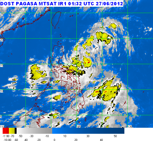
Severe Weather Bulletin Number 4 - June 27,2012 - Tropical Storm "DINDO"


Severe Weather Bulletin Number 4
Tropical Cyclone Warning: Tropical Storm "DINDO" (DOKSURI)
Issued at 11:00 a.m., Wednesday, 27 June 2012 

Tropical Storm "DINDO" has slightly intensified as it continues to move west Northwest towards Extreme Northern Luzon.  

--------------------------------------------------------------------------

Location of Center:   380 km East Northeast of Virac, Catanduanes or
(as of 10:00 a.m.)     490 km East Southeast of Casiguran, Aurora

Coordinates:   15.4°N, 127.5°E 

Strength:     Maximum winds of 75 kph near the center gustiness of up 90 kph

Movement:     West Northwest at 19 kph

Forecast Positions/Outlook:  

Thursday morning:   220 km Northeast of Casiguran, Aurora or
                              210 km East Northeast of Tuguegarao, Cagayan
Friday morning:
   150 km West Southwest of Basco, Batanes
Saturday morning:
   530 km Northwest of Basco, Batanes

---------------------------------------------------------------------------
Areas Having Public Storm Warning Signal  

Signal No. 2 (60-100 kph winds) 

  • Cagayan
  • Isabela  

Signal No. 1 (45-60 kph winds) 

  • Batanes Group of Islands
  • Calayan Island
  • Ilocos Norte
  • Apayao
  • Abra
  • Kalinga
  • Ilocos Sur
  • Mt.Province
  • Aurora
  • Ifugao
  • Nueva Viscaya
  • Quirino  

Residents living in low lying and mountainous areas, under public storm warning signal are alerted against possible flashfloods and landslides.

Estimated rainfall amount is from 15 - 25 mm per hour (heavy - intense) within the 400 km diameter of the Tropical Storm.

Tropical Storm "Dindo" is expected to enhance the Southwest Monsoon that will bring rains over Southern Luzon, Visayas and Mindanao especially the western section.

Fishing boats and other small seacrafts are advised not to venture out into the Eastern Seaboards of Central and Southern Luzon and Visayas due to the combined effect of Tropical Storm "DINDO" and the Southwest Monsoon.

The public and the disaster coordinating councils concerned are advised to take appropriate actions and watch for the next bulletin to be issued at 5 PM today. 

-----------------------------------------------------------------------------------------------
 PAGASA-DOST | June 27, 2012 | Article Link

Tuesday, June 26, 2012

Severe Weather Bulletin Number 1 - June 26,2012 - Tropical Depression Dindo


Severe Weather Bulletin Number 1
Tropical Cyclone Alert: Tropical Depression "DINDO"
Issued at 5:00 p.m., Tuesday, 26 June 2012

The active low pressure area east of Virac, Catanduanes has developed into a tropical depression and was named "DINDO". 
-------------------------------------------------------------------------


Location of Center:   670 km East Northeast of Virac, Catanduanes
(as of 4:00 p.m.) 

Coordinates:     14.2°N, 131.3°E

Strength:     Maximum winds of 55 kph

Movement:     West Northwest at 19 kph

Forecast Positions/Outlook:  

Wednesday afternoon:  520 km East of Casiguran, Aurora
Thursday afternoon:  320 km East of Aparri, Cagayan or 320 km Southeast of Basco, Batanes
Friday afternoon:  80 km North Northeast of Basco Batanes

------------------------------------------------------------------------

No Public Storm Warning Signals Raised

Estimated rainfall amount is from 10 - 15 mm per hour (heavy) within the 400 km diameter of the Tropical Depression.

Fishing boats and other small seacrafts are advised not to venture out into the Eastern Seaboards of Luzon and Visayas due to big waves generated by the effect of the Southwest Monsoon and Tropical Depression "DINDO".

The public and the disaster coordinating councils concerned are advised to take appropriate actions and watch for the next bulletin to be issued at 11 PM today.

-----------------------------------------------------------------------------------------------------
PAGASA-DOST | June 26, 2012 | Article Link

Saturday, June 16, 2012

Severe Weather Bulletin No. 7 - June 16, 2012


Severe Weather Bulletin Number SEVEN
Tropical Cyclone Alert: Typhoon "BUTCHOY" (GUCHOL)
Issued at 11:00 a.m., Saturday, 16 June 2012 

"BUTCHOY" has intensified into a typhoon and is now moving in a North Northwest direction.  
----------------------------------------------------------------------------------------

Location of Center:   470 km East Northeast of Borongan, Eastern Samar
(as of 10:00 a.m.) 

Coordinates:     13.2°N, 129.9°E 

Strength:     Maximum winds of 120 kph near the center
                  and gustiness of up to 150 kph 

Movement:      Moving North Northwest at 15 kph

Forecast Positions/Outlook:

Sunday morning:  590 km East Southeast of Casiguran, Aurora
Monday morning: 
500 km East Southeast of Basco, Batanes
Tuesday morning: 
690 km Northeast of Basco, Batanes

----------------------------------------------------------------------------------------

No Public Storm Warning Signals Raised

Typhoon "Butchoy" is expected to enhance the Southwest Monsoon that will bring rains over Luzon and Visayas especially over the western section which may trigger flashfloods and landslides.

Estimated rainfall amount is from 15 - 25 mm per hour (heavy) within the 500 km diameter of the typhoon.

Fishing boats and other small seacrafts are advised not to venture out into the seaboards of Luzon, Visayas and Eastern Mindanao due to the big waves generated by the effects combined effects of Typhoon "BUTCHOY" and the Southwest Monsoon.

The public and the disaster coordinating councils concerned are advised to take appropriate actions and watch for the next bulletin to be issued at 11 PM today.  

------------------------------------------------------------------------------------------------------------------
PAGASA-DOST | June 16, 2012 | Article Link

Friday, June 15, 2012

Severe Weather Bulletin No. 2 - June 14, 2012


Severe Weather Bulletin #2
Tropical Cyclone Alert: Tropical Storm "BUTCHOY" (GUCHOL)
Issued at 10:45 p.m., Thursday, 14 June 2012 

Tropical Storm "BUTCHOY" has slowed down and maintained its strength.  
----------------------------------------------------------------------------

Location of Center:   680 km East of Guiuan, Eastern Samar
(as of 10:00 p.m.) 

Coordinates:     10.8°N, 132.4°E 

Strength:     Maximum winds of 95 kph near the center
                  and gustiness of up to 120 kph 

Movement:     Moving West Northwest at 15 kph

Forecast Positions/Outlook:  

Friday evening: 450 km East of Borongan, Eastern Samar
Saturday evening:
500 km East of Baler, Aurora
Sunday evening:
280 km East of Basco, Batanes

----------------------------------------------------------------------------

No Public Storm Warning Signals Raised

Estimated rainfall amount is from 15 - 25 mm per hour (heavy) within the 300 km diameter of the Tropical Storm.

Fishing boats and other small seacrafts are advised not to venture out into the seaboards of Luzon, Visayas and Northeastern Mindanao due to big waves generated by the effect of the Southwest Monsoon and Tropical Storm "BUTCHOY".

The public and the disaster coordinating councils concerned are advised to take appropriate actions and watch for the next bulletin to be issued at 11 AM tomorrow.  

------------------------------------------------------------------------------------------------------------
PAGASA-DOST | June 14, 2012 | Article Link

Thursday, June 14, 2012

Severe Weather Bulletin No. 1


Severe Weather Bulletin #1
Tropical Cyclone Alert: Tropical Storm "BUTCHOY" (GUCHOL)
Issued at 11:00 a.m., Thursday, 14 June 2012 

The tropical storm over the Caroline Island has entered the Philippine Area of Responsibility (PAR) and was named "BUTCHOY".  
---------------------------------------------------------------------------------------------

Location of Center:  880 km East of Guiuan, Eastern Samar
(as of 10:00 a.m.) 

Coordinates:    11.0°N, 134.7°E 

Strength:    Maximum winds of 85 kph near the center
                  and gustiness of up to 100 kph 

Movement:    Moving West Northeast at 24 kph

Forecast Positions/Outlook:  

Friday morning:  560 km East of Virac, Catanduanes
Saturday morning:  320 km Northeast of Virac, Catanduanes

Sunday morning:  310 km Northeast of Aparri, Cagayan
 
---------------------------------------------------------------------------------------------

No Public Storm Warning Signals Raised

Estimated rainfall amount is from 15 - 25 mm per hour (heavy) within the 300 km diameter of the Tropical Storm.

Fishing boats and other small seacrafts are advised not to venture out into the seaboards of Luzon, Visayas and Northeastern Mindanao due to big waves generated by the effect of the Southwest Monsoon and Tropical Storm "Butchoy".

The public and the disaster coordinating councils concerned are advised to take appropriate actions and watch for the next bulletin to be issued at 11 PM today. 

---------------------------------------------------------------------------------------------------------------
PAGASA-DOST | June 14, 2012 | Article Link

Wednesday, June 13, 2012

WEATHER ADVISORY NO. 2 June 13, 2012


At 8:00 a.m. today, the Shallow Low Pressure Area (SLPA) was estimated based on satellite and surface data 210 km East of Northern Mindanao (9.5°N 128.0°E),while the Southwest Monsoon continues to affect Luzon. These weather systems will bring scattered to widespread rains over Northern Mindanao and the western section of Northern and Central Luzon.

Residents living in low lying areas and along mountain slopes are advised to be on alert for possible occurrence of flashfloods and landslides.

Meanwhile, a Tropical Storm (GUCHOL) was estimated 1,370 km East of Mindanao (9.3°N, 140.7°E) or over the Caroline Islands with maximum sustained winds of 65 kph near the center and gustiness up to 80 kph. It is moving Westward at 15 kph and is expected to enter the Philippine Area of Responsibility (PAR) tomorrow or early Friday and shall be named "BUTCHOY".

The next update will be incorporated in the public weather forecast at 5:00 p.m. today while the next advisory will be issued at 11:00 a.m. tomorrow. 

-----------------------------------------------------------------------------------------------------------
PAGASA-DOST | June 13, 2012 | Article Link

Tuesday, June 12, 2012

WEATHER ADVISORY NO.1 June 12, 2012


WEATHER ADVISORY NO.1
For: Shallow Low Pressure Area (SLPA)
Issued At: 11:00AM, 12 June 2012

At 10:00 AM today, The Shallow Low Pressure Area (SLPA) was estimated based on satellite and surface data at 100KM South of Mindanao (5N,124E). This weather system will bring mostly cloudy to cloudy skies with scattered to widespread rainshowers and thunderstorms over Mindanao particularly over Southern Mindanao and Zamboanga provinces.

Residents living in low lying areas and along mountain slopes are advised to be on alert for possible occurrence of flashfloods and landslides.

The next update will be incorporated in the public weather forecast at 5:00 PM today while the next advisory will be issued at 11:00 AM tomorrow. 

----------------------------------------------------------------------------------------
PAGASA-DOST | June 12, 2012 | Article Link

Saturday, June 02, 2012

‘Ambo’ blows till Monday; Coast Guard rescues 24 aboard motorbanca

The first storm of the rainy season is here. 

Tropical Storm “Ambo” brings wind, rain and choppy seas, ensuring a wet weekend and start of classes when public schools open on Monday.
The storm yesterday endangered a Bohol-bound motorbanca that stalled in the sea off Lawis Ledge, Talisay City.

All 24 people aboard the MB Salmin were safe with half of them rescued by a Coast Guard Search and Rescue Vessel an hour after the banca experienced engine trouble.

Twelve passengers transferred to the Coast Guard’s rubber boat and arrived at Pier 1, Cebu City at 3:30 p.m.

The other 12, including crew members, decided to stay in the banca while the engine was being fixed. The unregistered banca was on its way to Cabub-ian Island, Buenavista, Bohol province.

Storm “Ambo” is expected to leave the Philippines area of responsibility on Monday, said Bolivar Artiaga, weather specialist of Pagasa Mactan.

Cebu province will be spared from strong winds but must be alert for possible flashfloods and landslides brought by heavy rains, he said.

Expect cloudy skies with rains and a storm-itensified northeastern monsoon or Amihan, he said.

The Visayas and Mindanao will experience moderate to rough seas, especially in western Cebu.

The weather bureau declared the official start of the rainy season on May 31, Thursday.
In the next two months, rains will mostly occur late afternoon until evening, said Artiaga.
Since the storm has a small circulation, it is not expected to make landfall as it moves northeast to Japan.

Storm signal 1 was raised in Catanduanes, Camarines Sur, Camarines Norte, Polilio Island, Aurora and Isabela.

At least 19 storms visit the Philippines every year, although last year over 20 weather disturbances occurred.

Tropical Storm “Ambo” whose internationally name is “Mawar” was located 190 kilometers northeast of Virac, Catanduanes with winds of 65 kph to 80 kph.

The MB Salmin was “dead-in-the-water” around 1:30 p.m. yesterday shortly after leaving Pasil port in Cebu City. It later drifted to shallow waters between the former Kawit Island in Cebu City and islets in Cordova town.

Cebu Coast Guard Commander Rolando Punzalan, Jr. said the unregistered motorbanca was operated by Roger delos Santos of Cabui-an, Bohol.

Coast guard personnel later found a foot-long crack in the pre-board of the motorbanca which may have been caused by strong waves.

Punzalan said they were able to restore normal operations of the engine. The motorbanca was brought to Tongo Island, Cebu where the crew wanted to keep it overnight for repair.

The rescued persons were identified as Efren CaƱizares, 46; Nelson Tabay, 31; Flaviana Primacio, 52; Neil Ace Gador, 28; Francis Lapu-Lapu, 11; Christian Lapu-Lapu, 16; Jenith Llanto, Florentino Primacio, 58; Rebecca Abellar, 15; Jotelen Angiol, 16; and Evamae Minguito, 15.

-----------------------------------------------------------------------------------------------------------
/The Philippine Daily Inquirer | June 2, 2012 | Article Link

Featured Posts

AFP Modernization 2017: Highlights and Review

The modernization of the Armed Forces of the Philippines was on a roll this year, as we've seen a few big ticket items having completely...

Popular Posts