Severe Weather Bulletin #1
Tropical Cyclone Alert: Tropical Storm "BUTCHOY" (GUCHOL)
Issued at 11:00 a.m., Thursday, 14 June 2012
Tropical Cyclone Alert: Tropical Storm "BUTCHOY" (GUCHOL)
Issued at 11:00 a.m., Thursday, 14 June 2012
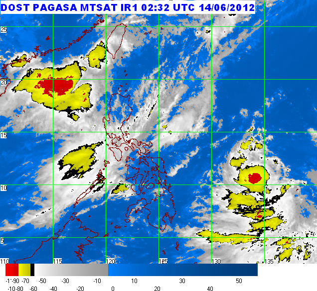
The tropical storm over the Caroline Island has entered the Philippine Area of Responsibility (PAR) and was named "BUTCHOY".
---------------------------------------------------------------------------------------------
Location of Center: 880 km East of Guiuan, Eastern Samar
(as of 10:00 a.m.)
(as of 10:00 a.m.)
Coordinates:
11.0°N, 134.7°E
Strength:
Maximum winds of 85 kph near the center
and gustiness of up to 100 kph
and gustiness of up to 100 kph
Movement:
Moving West Northeast at 24 kph
Forecast Positions/Outlook:
Friday morning: 560 km East of Virac, Catanduanes
Saturday morning: 320 km Northeast of Virac, Catanduanes
Sunday morning: 310 km Northeast of Aparri, Cagayan
Saturday morning: 320 km Northeast of Virac, Catanduanes
Sunday morning: 310 km Northeast of Aparri, Cagayan
---------------------------------------------------------------------------------------------
No Public Storm Warning Signals Raised
Estimated rainfall amount is from 15 - 25 mm per hour (heavy) within the 300 km diameter of the Tropical Storm.
Fishing boats and other small seacrafts are advised not to venture out into the seaboards of Luzon, Visayas and Northeastern Mindanao due to big waves generated by the effect of the Southwest Monsoon and Tropical Storm "Butchoy".
The public and the disaster coordinating councils concerned are advised to take appropriate actions and watch for the next bulletin to be issued at 11 PM today.
---------------------------------------------------------------------------------------------------------------
PAGASA-DOST | June 14, 2012 | Article Link


No comments:
Post a Comment